Monarch Pass is a high mountain pass in the Colorado Rockies along the Continental Divide. Monarch Summit is located on U.S. Highway 50, approximately 17 miles west of Ponca Springs, Colorado. U.S. Highway 50 is the southern route across the state of Colorado and connects with I-70 about 20 miles east of Utah. U.S. Highway 50, on both sides of Monarch Summit is a classic steep, windy, mountain shelf road. Monarch Pass receives a large amount of snow in the winter and often either has chain restrictions for commercial trucks or is closed for avalanche control.
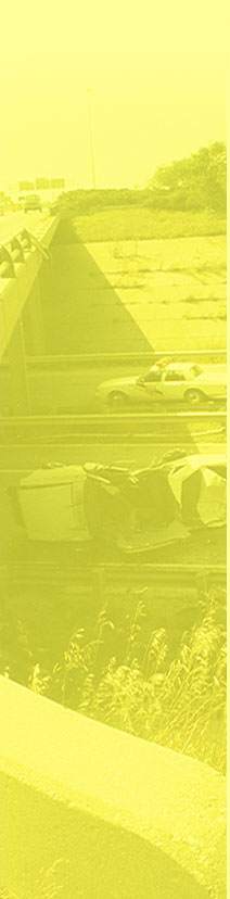
Westbound U.S. 50 from the Monarch Summit has a vertical descent of 2,649 feet over a distance of 8.7 miles. The reported grade for the westbound descent is 6% for 9 miles. The westbound descent is steady over the 8.7 miles before flattening to a gradual descent for a few more miles. The descent has numerous marked advisory curves, the lowest having advisory speeds of 30 mph. At 2.9 miles west of the summit there is a sharp curve hidden behind a rock wall. This curve has a 35-mph advisory speed, however, the curve sign is not visible until you are into the curve. The road at this location is covered with skid marks from trucks, so be careful! A highway department maintenance facility is about 9 miles west of the summit where highway maintenance trucks entering or leaving the driveway should be expected. Approximately 10 miles west of the summit, there is a town with a gas station and other businesses, so traffic should be expected here also.
Eastbound U.S. 50 from the Monarch Summit has a vertical descent of 3,009 feet over a distance of 10.4 miles. The grade is reported to be 6% over 10 miles. The descent is stepped with grades varying from very steep to moderate. Although, the descent is windy, it is not as extreme as the westbound descent. There are numerous marked advisory curves on the descent, the lowest being two 35 mph curves a short distance from the summit. The grade bottoms out at 10.4 miles, where there is a slight upgrade before lessening to a mild descent into Ponca Springs. At Ponca Springs, there is a highway junction requiring a stop at about 17 miles east of the summit, and an elevation of 7,437 feet.
On the eastbound descent from Monarch Summit, there is a ski area on the left side of the road 1.6 miles from the summit. Traffic will be encountered here, particularly in the morning and afternoon during the ski season. Additionally, at about 5 miles east of the summit, there is a business area with parking lot entrances on both sides of the highway and traffic should be expected here. Lastly, a highway department maintenance facility is about 10 miles east of the summit where highway maintenance trucks entering or leaving the driveway should be expected.
SUMMIT
Pass Name:
Monarch
Traversed by Highway:
US 50
Summit Elevation:
11,312 ft
Summit Conditions:
Pullout to north / parking area, gift shop, and scenic overlook to south
Summit Milepost:
199
WEST DESCENT
Base Elevation:
8,663 ft
Vertical Distance:
2,649 ft
Base Milepost:
190
Driving Distance:
8.7 miles from summit
Posted Speed Limit:
45 mph
Steepest Reported Grade:
6% for 9 miles
Calculated Average Grade:
5.7% for 8.7 miles
Lowest Advisory Speed:
30 mph at 5.7 miles from summit
Number of Lanes:
One westbound and two eastbound
Number of Switchbacks:
None
Number of Advisory Curves:
Nineteen
Runaway Ramps:
One on right 5.0 miles from summit
Number of Brake Check Stations:
One at summit
Number of Required Stops:
None
ADVISORY SPEED CURVES
Advisory Speed
Location from Summit
Sign
35 mph
0.1 miles
Left Curve
35 mph
0.7 miles
Right Windy Road
40 mph
1.2 miles
Left Curve
35 mph
1.9 miles
Right Reverse Curve
35 mph
2.9 miles
Left Reverse Curve
40 mph
3.2 miles
Right Windy Road
35 mph
3.8 miles
Right Curve
None
4.1 miles
Right Curve
35 mph
4.3 miles
Right Reverse Curve
35 mph
4.8 miles
Right Curve
35 mph
5.1 miles
Left Reverse Curve
None
5.4 miles
Right Curve
30 mph
5.7 miles
Right Windy Road
None
6.2 miles
Right Reverse Curve
None
6.5 miles
Left Curve
55 mph
7.5 miles
Left Curve
60 mph
7.8 miles
Right Curve
55 mph
8.3 miles
Left Curve
None
8.7 miles
Left Curve
RECOMMENDED SPEEDS FROM THE GRADE SEVERITY RATING SYSTEM
MAXIMUM TRUCK WEIGHT (POUNDS)
MAXIMUM SAFE SPEED (MPH)
BRAKE TEMP FROM DECLINE (°F)
BRAKE TEMP FROM EMERGENCY STOP (°F)
TOTAL BRAKE TEMP. (°F)
TOTAL TRAVEL TIME (MIN.)
80,000
15
489
5
494
34.8
75,000
17
484
6
490
30.7
70,000
20
483
8
491
26.1
65,000
25
483
12
495
20.9
60,000
30
457
16
473
17.4
55,000
43
467
31
498
12.1
50,000
45
399
31
430
11.6
*These speeds are based on an average grade from the summit to the base. Some grade segments may be steeper than the average and require a slower speed.
Monarch Pass Westbound
EAST DESCENT
Base Elevation:
8,303 ft
Vertical Distance:
3,009 ft
Base Milepost:
210
Driving Distance:
10.4 miles from summit
Posted Speed Limit:
45 mph
Steepest Reported Grade:
6% for 10 miles
Calculated Average Grade:
5.4% for 10.4 miles
Lowest Advisory Speed:
35 mph at 0.1 and 0.3 miles from summit
Number of Lanes:
Three
Number of Switchbacks:
None
Number of Advisory Curves:
Fourteen
Runaway Ramps:
One at 4.7 miles from summit
Number of Brake Check Stations:
One at summit
Number of Required Stops:
One at 17.3 miles from summit
ADVISORY SPEED CURVES
Advisory Speed
Location from Summit
Sign
35 mph
0.1 miles
Left Curve
35 mph
0.3 miles
Right Curve
None
0.7 miles
Right Curve
None
1.6 miles
Right Curve
None
2.1 miles
Left Curve
None
2.9 miles
Right Curve
45 mph
4.1 miles
Left Curve
None
4.6 miles
Left Curve
40 mph
5.0 miles
Right Curve
None
5.3 miles
Right Curve
None
6.6 miles
Left Curve
None
9.1 miles
Left Curve
None
9.3 miles
Left Curve
None
9.6 miles
Right Curve
RECOMMENDED SPEEDS FROM THE GRADE SEVERITY RATING SYSTEM
MAXIMUM TRUCK WEIGHT (POUNDS)
MAXIMUM SAFE SPEED (MPH)
BRAKE TEMP FROM DECLINE (°F)
BRAKE TEMP FROM EMERGENCY STOP (°F)
TOTAL BRAKE TEMP. (°F)
TOTAL TRAVEL TIME (MIN.)
80,000
15
467
5
481
41.6
75,000
17
474
6
480
36.7
70,000
20
476
8
484
31.2
65,000
25
481
12
493
25.0
60,000
30
454
16
470
20.8
55,000
41
468
28
496
15.2
50,000
45
396
31
427
13.9
*These speeds are based on an average grade from the summit to the base. Some grade segments may be steeper than the average and require a slower speed.