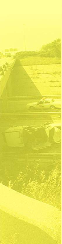
Vail Pass is a high mountain pass in the Colorado Rockies just west of the Continental Divide. Vail Summit is located on Interstate 70, about 10 miles east of the town of Vail, Colorado. I-70 on both sides of the Vail Pass Summit has a steep descent. Vail Pass is one of three steep grades on I-70 between Denver and Utah with Eisenhower Pass to the west and Floyd Hill to the east. Vail Pass receives a large amount of snow in the winter and often has chain restrictions for commercial trucks.
Westbound I-70 from the Vail Summit has a vertical descent of 2,267 feet over a distance of 9.4 miles. The reported grade for the westbound descent is 7% for 7 miles. The grade is steady for approximately 5 miles, where it flattens for a 1/2 mile or less before continuing its steep descent for about 4 more miles.
Eastbound I-70 from the Vail Summit has a vertical descent of 1508 feet over a distance of 12.7 miles. The eastbound descent is stepped with grades varying from steep to moderate. At the 195 milepost, the grade flattens for about a mile before continuing a lesser descent to the 205 milepost, where an uphill transition is encountered. Several ski areas are located in this area and traffic, particularly in the morning and late afternoon during the ski season, should be expected at the exits between mileposts 195 and 205.
SUMMIT
Pass Name:
Vail
Traversed by Highway:
I-70
Summit Elevation:
10,662 ft
Summit Conditions:
Large pull out on right side of summit
Summit Milepost:
189
WESTBOUND DESCENT
Base Elevation:
8,395 ft
Vertical Distance:
2,267 ft
Base Milepost:
179
Driving Distance:
9.4 miles
Posted Speed Limit:
65 mph / Trucks over 15 tons, 45 mph
Steepest Reported Grade:
7% for 7 miles
Calculated Average Grade:
4.5% for 9.4 miles
Lowest Advisory Speed:
55 mph at 3.0 miles from summit
Number of Lanes:
Two westbound
Number of Advisory Curves:
Four
Runaway Ramps:
One on right at 3.5 miles from summit. One on right at 7.0 miles from summit.
Brake Check Stations:
One at summit
ADVISORY SPEED CURVES
Advisory Speed
Location from Summit
Sign
60 mph
1.2 miles
Right Curve
60 mph
2.5 miles
Right Curve
55 mph
3.0 miles
Left Curve
60 mph
3.9 miles
Left Curve
ELEVATIONS
Mile Marker
Elevation
Change in Elevation
Percent Grade
189
10,662 ft.
188
10,495 ft.
167 ft.
3.1%
187
10,231 ft.
264 ft.
5.0%
186
9,967 ft.
264 ft.
5.0%
185
9,592 ft.
375 ft.
7.1%
184
9,337 ft.
255 ft.
4.8%
183
9,113 ft.
224 ft.
4.2%
182
8,826 ft.
287 ft.
5.4%
181
8,658 ft.
168 ft.
3.1%
180
8,530 ft.
128 ft.
2.4%
179
8,395 ft.
135 ft.
2.5%
RECOMMENDED SPEEDS FROM THE GRADE SEVERITY RATING SYSTEM
MAXIMUM TRUCK WEIGHT (POUNDS)
MAXIMUM SAFE SPEED (MPH)
BRAKE TEMP FROM DECLINE (°F)
BRAKE TEMP FROM EMERGENCY STOP (°F)
TOTAL BRAKE TEMP. (°F)
TOTAL TRAVEL TIME (MIN.)
80,000
25
479
15
494
22.6
75,000
30
464
20
484
18.8
70,000
32
477
22
499
17.6
65,000
55
438
61
499
10.3
60,000
60
369
67
436
9.4
*These speeds are based on an average grade from the summit to the base. Some grade segments may be steeper than the average and require a slower speed.